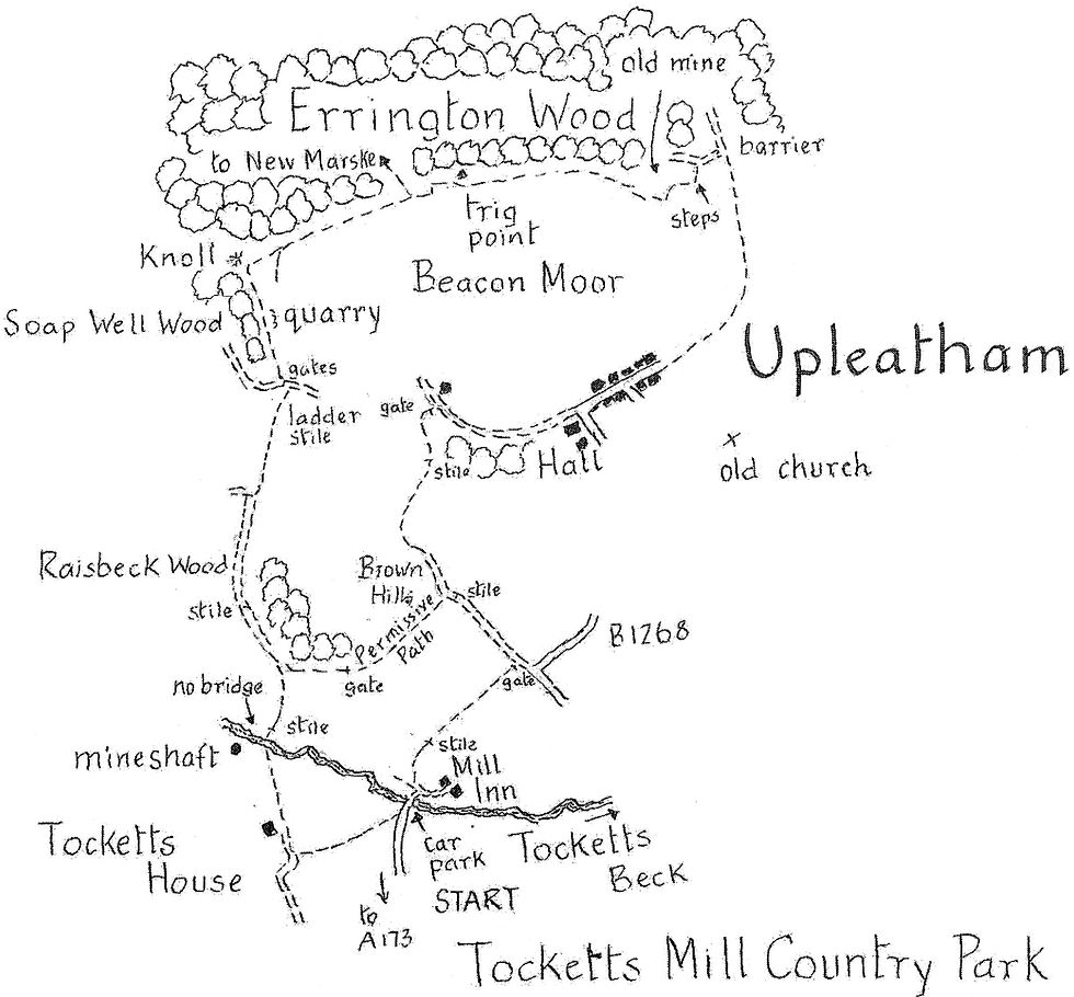
Upleatham to Skelton & Tocketts Mill
- Apr 10
- 4 min read
The low lying hills that flank Skelton Beck offer distant panoramic views of the national park's moors and coast. They are also well endowed with public rights of way.
This 7 mile walk starts from Upleatham, crosses the beck and heads for Skelton before following the Cleveland Way over Airy Hill. The return is made via Tocketts Mill. An add-on of less than 2 miles is also mapped giving the opportunity for an extension or of course for a short walk in its own right.

Distance: 7 miles (or 9 miles if Beacon Moor is included)
Time: 4 or 5 hours
Grade: easy
Conditions: well marked field paths and tracks
Refreshments: Green Inns, Skelton Green and Tocketts Mill
OS Explorer Map 306
Originally published: 2 December 2011
We start from the T junction at the west end of Upleatham village (GR 632193). With the war memorial and a covered well head on your right walk down the village street past the Wesleyan chapel of 1862 and then the church of St. Andrew of 1835 by Ignatius Bonomi, now a private dwelling.
Turn right at the post box. Good views open up of the Skelton valley with a glimpse of the remains of the Skelton Park iron mine on the far hillside. At the B1268 Guisborough-Saltburn road turn left to the 12th century church, once the centre of the Domesday village of Upelider, meaning upper slopes, but now isolated in its graveyard. It's often claimed to be the country's smallest church but 2 centuries of stone robbing has reduced it to this remnant of the nave. A few carved gargoyles hint of a more prosperous past.
From the far side of the churchyard take the indistinct path signed down across fields to Skelton Beck After the footbridge turn left along the possibly muddy bank to another bridge over a side stream. The path then emerges from trees and climbs up to the A 173 Guisborough-Skelton road.
Follow the road left for some 500 yards. The first lane on the left leads to the oldest part of Skelton. The church, though mainly 18th century, has a medieval chancel. It is cared for by the Churches Conservation Trust - key available nearby. It is built within the site of the castle of the Norman de Brus family who were given a huge estate in the area in 1091. On the far side of the church there's a good view of the extensive castle bailey, now the gardens of the 18th century Skelton Castle. On the east side of the churchyard there's evidence of the deep moat which once encircled the castle and church.
Return to the main road and cross straight over through a gate. There are traces of a stone causeway as you follow the path up to Back Lane Farm. Beyond the farm follow the access lane to the left and in 100 yards turn right through allotments to Manless Green Farm. Again bear left past the end of Cleveland View to join the Cleveland Way in about 200 yards. To the left, on Airy Hill Lane is Green Inn (Walkers Welcome, open daily 11-30).
Our walk follows Airy Hill Lane in the opposite direction as it climbs gently as an unsurfaced farm track. It's worth looking back at intervals along here to enjoy the stupendous views of the sea and the cliffs which gave Cleveland its name. Beyond Airy Hill Farm Cleveland's inland cliffs come into sight with Highcliff Nab prominent and the tip of Roseberry Topping just visible.
The Cleveland Way soon starts its decent. Where it goes sharp left over a stile continue ahead on a bridleway which drops through the trees and soon opens to yet more views, this time of Guisborough, the Eston Hills and Redcar. The path bears right with a sweeping vista to the right across Skelton Park, once the hunting demesne of the lords of the castle.
The path then crosses the deeply incised Waterfall Beck. Follow the access track beyond Waterfall Farm and, just before it joins the A 171, bear right on Mucky Lane, a bit of a misnomer though to be fair it has a good line in lengthy pools after rain. In half a mile it reaches the former A 173 which you must follow, right, to reach the realigned road through a gate.
Cross over and head for the slip lane for Tocketts Mill Country Park. In some 400 yards you cross Tocketts Beck into an extensive caravan site in a very attractive woodland setting. Opposite the restaurant (open daily) is the corn mill, mentioned in medieval records The building you see today though is mainly of the 19th century. Its machinery was restored by sixth form students some 30 years ago and is open as a working mill in the summer.
Return from the mill to the bridge. Do not cross it but instead go right on a tarred avenue and after the second caravan bear right to a footpath post on the edge of the trees. The path is easy to follow up through the wood and then across a couple of fields to a farm track.
Go left up it on to the Brown Hills where there are excellent views down the valley of the Skelton Beck to the sea. The right of way then flattens out and bears to the right to a junction of paths just below a large barn.
Here you have a choice. The track to the right through a gate leads in about 400 yards down through the trees to our starting point.
You will not be disappointed if, on the other hand, you decide to follow the 2 mile extension. Take the track to the left which climbs over one field to a gate. Continue ahead on a path which includes a couple of right hand bends before it reaches the edge of Errington Wood.
Stay out of the trees by turning right on a permissive path which makes a short climb to the trig point at over 600ft on Beacon Moor. It then continues above the trees with outstanding views of the coast between Huntcliff, Teesmouth and Hartlepool. The path completes the circle by returning to the large barn mentioned 3 paragraphs above.
Comments