Tocketts Mill to Upleatham & Errington Wood
- Nov 13, 2021
- 4 min read
Updated: Apr 10
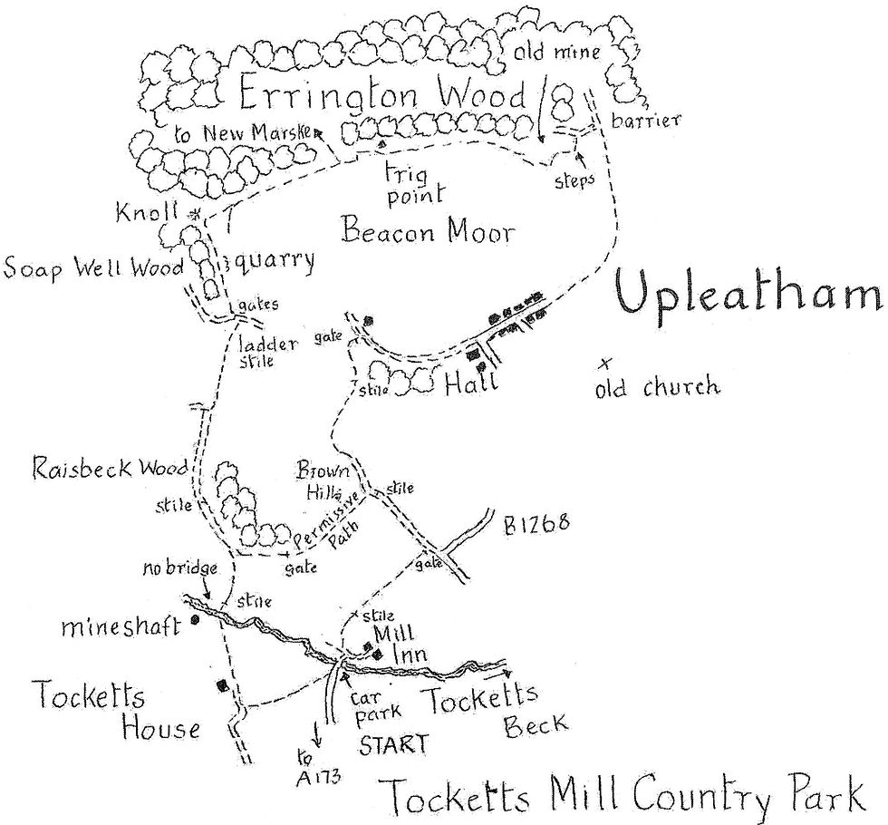
The low lying hills that flank Skelton Beck afford distant widespread views of the national park's moors and coast. A network of well-maintained rights of way allows for gentle exploration. This 6-mile walk starts from Tocketts Mill Country Park which is sited in attractive woodland some two miles from Guisborough. The owners welcome walkers who are requested to use the large car park before the bridge over Tocketts Beck (GR 627181).
Distance: 6 miles
Time: 3 hours
Grade: easy
Conditions: well signed footpaths and bridleways
Refreshments: Tocketts Mill Inn
OS Explorer Map OL26 or 306
Originally published: 30 June 2016
Opposite the Inn is the corn mill, mentioned in medieval records though the building you see today is mainly of the 19th century. Its machinery was restored by sixth formers some 30 years ago and it is open as a working water mill producing flour every Sunday and Bank Holiday Monday from the first Sunday in luly to the last Sunday in September, 2 to 4 pm.
From the car park cross the beck, a tributary of Skelton Beck and turn sharp left to pick up the public right of way between caravans 4 and 5. The path soon climbs from the valley and there are good views to the right across to Skelton Park, once the hunting lands of the lords of Skelton Castle.
After one field turn left at a gate. Follow the farm track up the slope of Brown Hills. The right of way then flattens out and bears to the right to a junction of paths just below a large barn. Turn right down a stony lane into Upleatham.
On the right just before the junction is the Hall, built last century to replace the earlier house of the Zetland family which suffered from mining subsidence. The handsome circular plaque in the main gable of the present use once decorated a building in the south.
We continue ahead along the village street. On the right is the war memorial and a covered well head followed by the Wesleyan chapel of 1862 and then the church of St. Andrew of 1835, by Ignatius Bonomi, now a private house.
The street continues as a bridleway and from it there are views of the 12th century church, once the centre of the the Domesday village of Upelider (meaning upper slopes) but now isolated from the rest of the village by the B 1268. It is often claimed to be the country's smallest church but two centuries of stone robbing have reduced it to its present size. Below the church and peeping above the trees is the early 19th century Skelton Castle, built on the site of the medieval castle of the de Brus family.
In about half a mile the bridleway enters Errington Wood. At a steel barrier turn left uphill on another bridleway to a welcome seat with stunning views across to Saltburn and Huntcliff. Then climb the steps behind this vantage point. The path skirts the overgrown site of the East Winning section of Upleatham Mine.
Bear right when you emerge from the trees and follow the edge of the wood on a permissive path to a trig point, 600ft up on Beacon Moor. The reward for this gentle ascent is the best vien of the walk. On a clear day the coast north is visible for at least 15 miles and takes in Redcar, Teesmouth and Hartlepool. To the south is Huntcliff and the moorlands beyond. Below you are the houses of New Marske. The earliest houses were built in the 1850s for the 500 miners employed in Upleatham Mine. Worked initially by the Derwent IronCompany and, after 1857, by JW Pease and Co. it was Cleveland's second largest mine. It was one of the easiest to work and in the 1860s and1880s produced over half a million tons of iron ore each year. It closed in 1923. Its success however, had serious consequences for, by the end of the 19th century as it was extended under Beacon Moor, it caused subsidence to cottages and farmhouses in addition to Upleatham Hall.
Our walk continues for another 500 yards along the edge of the wood. Ignore a path to the right which heads down through Errington Wood to New Marske and instead continue to the far end of the field to a little knoll crowned with trees. Re-enter the wood at this point and, leaving the knoll on your right, follow a path through the trees of Soap Well Wood and past a disused ironstone quarry. In another 200 yards the path reaches a kissing gate and emerges from the wood.
Turn left through an adjacent kissing gate and head for a ladder stile 100 yards away. From the stile a path drops across fields back into the valley of the Tocketts Beck with distant views of Guisborough, the Cleveland Hills and Roseberry Topping.
The path then joins a field track. Continue along to where it bends to the left around the edge of Raisbeck Wood. Here, at a noticeboard on the left in the trees, the public right of way leaves the track and heads downhill to the beck. However this cannot be recommended as floods have washed away the footbridge and the rapidly flowing stream is unfordable. Only if you wish to view the remaining shaft of the short lived Tocketts Mine (on the far side of the beck) is it worth walking down to the beckside. There is also no public access along the beck to Tocketts Mill.
Fortunately, from the noticeboard a permissive path has been created along the track on the edge of Raisbeck Wood. It continues over Brown Hills to our outward route where turn right.

Comments