Middleham into Coverdale
- Dec 1, 2020
- 4 min read
Updated: Apr 22, 2021
One of the most attractive of Yorkshire's smaller dales, 12 mile long Coverdale merges into Wensleydale at Cover Bridge, a mile and a half east of Middleham, the starting point for this 7 mile walk.
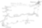
Distance: 7 miles
Time: 3 hours
Grade: moderate
Conditions: well-marked field paths and open moorland
Refreshments: Middleham
OS Explorer Map OL30
Originally published: 25 January 2008
The ruins of the formidable castle dominate the tiny town. It was started in 1170 by Robert Fitz Ralph and progressively expanded for the next three centuries. It became a stronghold of the Nevilles but its most famous resident was Richard, Duke of Gloucester who used it as his principal home after marrying Anne Neville, daughter of Warwick the Kingmaker. He visited it even after he had been proclaimed king as Richard III in 1483.
We leave Middleham by following the lane on the left side of the castle. Away to the right are the remains of William's Hill, a motte and bailey castle built a century earlier to guard the route from Richmond via Coverdale to Wharfedale and Skipton. Our path continues
over fields and across a low saddle down towards the Cover which can soon be heard in the distance. The high limestone crags of Cover Scar on the far bank are testimony to the erosive power of the river which rushes through a miniature gorge below.
Our path bears right, away from the steep drop to the riverside and continues towards a line of conifers. Here there are two stiles to cross before we descend to the river bank at Hullo Bridge. The curious name is probably a corruption of the Scandinavian personal name Ulla.
Cross the bridge and follow the track which climbs gently towards Braithwaite Hall, a handsome three gabled farmhouse of 1667, originally a grange of Jervaulx Abbey. It is now owned by the National Trust and open only by appointment.
Turn right opposite the hall driveway and along the lane from East Witton to Coverham.In a quarter of a mile go half left over a stile signed to Caldbergh. The route is indistinct buit there is a marker post 200 yards up on the hillside followed by a plantation of conifers which you should keep on your right. There are fine views too from here down to Coverham church away on the right and over the valley to the looming bulk of Middleham Low Moor.
After passing the plantation the way is easy to follow and within half a mile joins the access track from the 18th century farmhouse of Ashes. This leads into Caldbergh, a village of grey stone houses, the finest being Manor Farm, reputedly the site of the birthplace of Miles Coverdale, translator of the Bible into English during the Reformation. The present house is dated 1685 on its east facade which can best be seen down the path marked to Hang How Lane on the right as you descend through the village.
Our route continues down the village street to the narrow lane which threads the southern side of Coverdale. Turn right and at the first bend, where the road crosses a stream, look up right for a good example of the many limekilns which were found throughout the dales in the 19th century. In another quarter of a mile where, just beyond a barn, the road swings to the right. Bear left on an unmarked but well preserved hollow way which descends to the deep ford through the river at Bird Ridding. Beyond the footbridge the lane climbs past Bird Ridding Farm to the main valley road.
Go right and then almost immediately left on a bridleway between the imposing gate posts of Tupgill Park, now well known for its amazing sculptures and children's amusements. These of course are out of view.
The tarred bridleway divides before you reach the house, but bothbranches lead through on to Middleham Low Moor. The left hand branch goes past the house and climbs as a concrete track to the racing stables of Ashgill. Turn right when you reach the moor. The alternative bridleway follows the access route for visitors and then continues past two attractive pools, a waterfall and a fishing lodge to Fern Gill and a gate on to the moor. Here again you should turn right.
In the mornings, from 6 am to 1 pm, many of the 400 or so horses stabled around Middleham are excercised over this common access land. During these hours you should keep to the designated rights of way over the moor. These are marked on a board as you enter the moor from Middleham, but there are no similar boards from either the Ashgill or Fern Gill entrances, so I have marked the most direct of the designated bridleways on the map.
From the Fern Hill gate for some 250 yards follow the rough track along the side of the wall which encloses the moor. Then strike off left up a short rise over the rough moorland. At the top there are fine views into both Wensleydale and Coverdale. Keep a trig point some 150 yards on your left and then descend parallel to the fenced all weather gallops to the road at the far end of the moor almost a mile distant, (and where the noticeboard is sited).
At this point, if you do not wish to follow the road back into Middleham, cross the road to a wicket gate, from which a path runs behind the town to the castle.