Healey to Ellingstring & Colsterdale
- Dec 2, 2020
- 4 min read
Updated: Jan 15, 2021
The countryside west of Masham is one of rushing streams set in well wooded valleys separated by extensive tracts of low lying moorland. It is still relatively isolated and little frequented by walkers. I met none on the reconnaissance for this 9 mile route.
Distance: 9 miles
Time: 5 hours
Grade: moderate
Conditions: some missing signs, but paths and tracks in good state
Refreshments: Fearby and Masham
OS Explorer Map OL26 and 302
Originally published: 16 May 2008
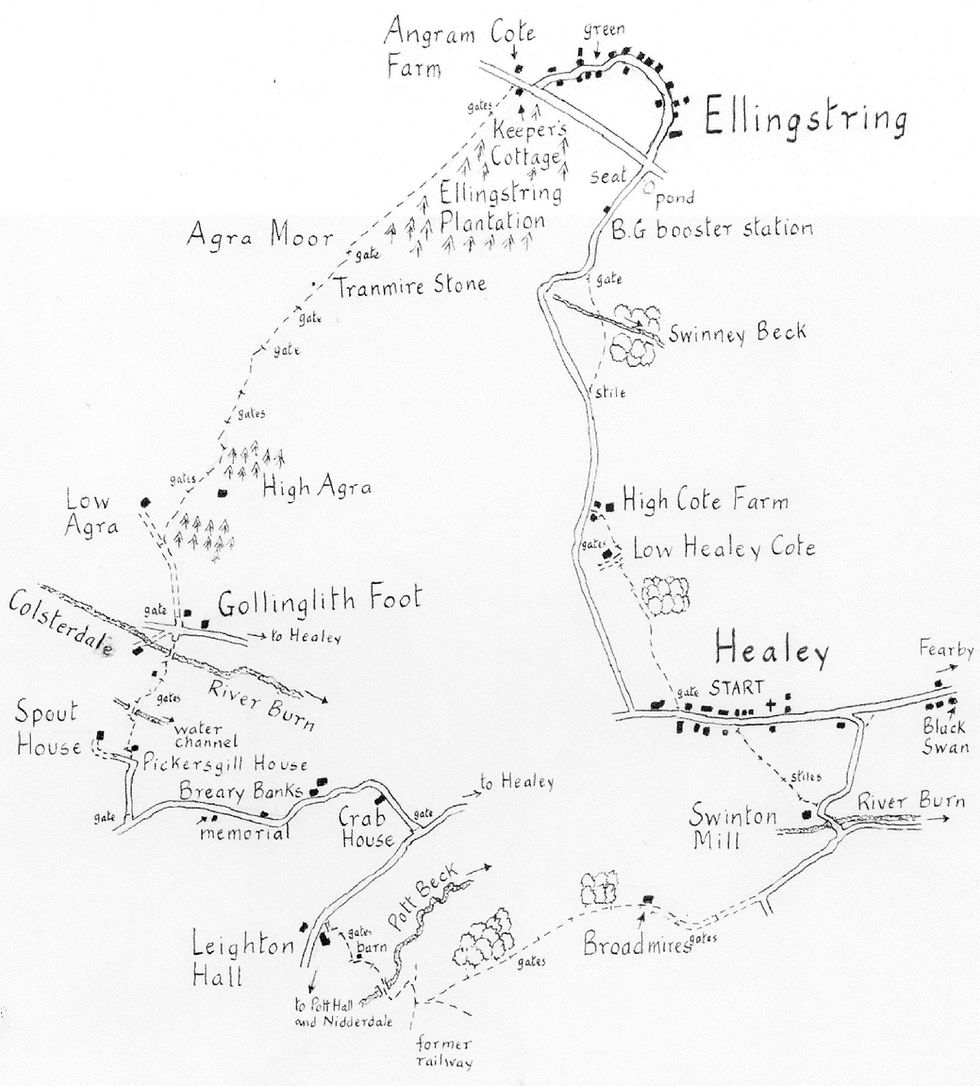
We start from the imposing parish church of Healey, built in 1848 at the edge of the village, (GR 183807). Its spire dominates the valley of the River Burn which we traverse in the later stages of the walk.
Go along the village street for some 300 yards to a large 'Please Close This Gate' sign on the right. The path on the other side is indistinct but rises gently across a long field to Low Healey Cote. Go right, around the back of the farm and cross one more field to High Cote Farm where you join a lane, (mapped as an easier alternative from Healey).
Go right and, in 200 yards, where the road bends to the left, look out for a stile on the right. The path cuts a corner and rejoins the road after a very attractive crossing of Swinney Beck. Turn right up to an ugly but prominent stone building which, a local assured me, was built to house a booster aerial for BG vans!
A few yards further and you reach a well used duck pond at a cross roads where there are extensive views down into Wensleydale. Go straight ahead if you wish to explore the pretty village of Ellingstring. The lane curves round in a semi-circle of houses passing a small green, (with picnic benches), before rejoining the more direct route from the pond at Keeper's Cottage.
Go right at the cottage and in about 20 yards, opposite Angram Cote Farm, turn left through a metal gate and up over a field, keeping parallel to Ellingstring Plantation over on the left. We are now following an important medieval route over Agra Moor used by Jervaulx Abbey which in the 14th century was granted rights for extracting coal and iron in Colsterdale where the monks had a grange. The route continued from the dale over Pott Moor to Lofthouse in Nidderdale.
In about 300 yards, and just before striking uphill to a gate on the horizon, look out for the triangular Tranmire Stone embedded in the wall on the right. It marks the former boundary between East Witton and the medieval Peculier of Mashamshire after which the famous Masham beer is named.
The path, with its views over the open moors, is a delight to follow and you are likely to be accompanied by the cries of lapwings, curlews and pipits. On the descent into Colsterdale you pass several deep, rutted hollow ways on the right, evidence that this was a well used
route.. At the bottom we join the track from Low Agra Farm and arrive at the attractive hamlet of Low Gollinglith where the busy River Burn rushes over a ford. You could go left here back along the road to Healey and save two miles.
Our main walk, however, goes over the footbridge and left, along a well signed bridleway which soon leaves the river to climb the valley side. In about half a mile it crosses a deep concrete water channel, built by Leeds Corporation a century ago as part of their unrealised
plans to construct a reservoir in Colsterdale. The path then heads up to the empty Pickersgill House and the approach track to Spout House Farm.
Go left on the track up to a junction where turn left along a tarred lane for about three quarters of a mile. On the right, on the slopes of Breary Banks, is the site of the hutted encampment used by the workers who built Leighton Reservoir for Leeds Corporation at the
beginning of last century. The huts were then used from September, 1914, as a training camp by the 15th Battalion The West Yorkshires, the Leeds Pals, my father's regiment. From here, in 1915, the battalion was sent, first to Egypt and then to France where it suffered enormous casualties in the Battle of the Somme. It's a poignant spot, still commemorated annually at the memorial erected in 1935.
The lane descends past Crab House to a junction where, again, a short cut could be made, left, along the road back to Healey. Our walk, however, goes right, uphill on the road which leads into upper Nidderdale. After a quarter of a mile turn left on a bridleway in front of the venerable 17th century Leighton Hall. You head towards a large barn before passing behind it and dropping down to a sturdy bridge over Pott Beck. In her book, "In Days of Yore", Susan Cunliffe-Lister conjectures that this was part of another monastic route linking Fountains Abbey with its grange at Pott. We follow it for the next mile.
The right of way zig zags up the bank on the far side, crossing, half way up, the line of the narrow gauge railway built in 1902 for the construction of Roundhill Reservoir. At the top of the bank, by two timber posts, the bridleway divides. Go half left here on a green way across fields with good views of the spire at Healey away to the left. From Broadmires the bridleway follows the farm track to a road junction. Go left here down to another junction and turn left over the Burn.
In 100 yards the road swings left, away from the river. Take a stile on the left just after the entrance to the former Sawley saw mill. The path heads up to Healey. A line of power poles acts as markers in the last two fields.


Comments