Helmsley up Beck Dale, returning past Rievaulx Abbey
- David Swabey
- Nov 5, 2022
- 4 min read
Updated: Nov 13, 2022
Until the 19th century Borough Beck, the busy little stream that tumbles through Helmsley provided a permanent clean water supply for the townsfolk who lived in the shadow of the Norman castle.
In fact so valuable was it that those who polluted it were sometimes brought to justice, like James Boyes and 8 others in 1735 for washing yarn in the beck, or William Cort in 1742 for allowing his maid to wash nappies there or Mary Conning in 1800 who diverted the stream for her own use in a very dry season, 'leaving the Town without water in case of an Accident by Fire',
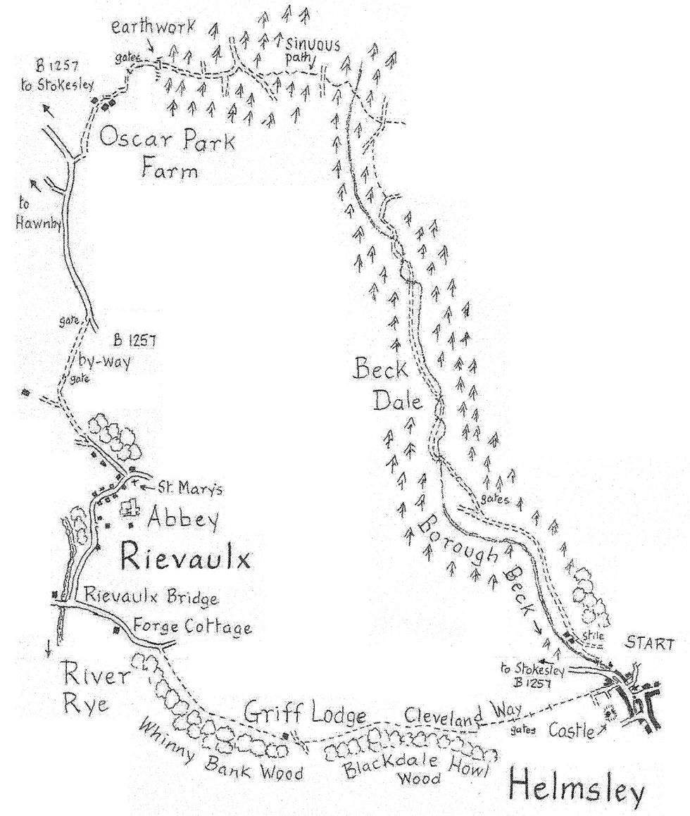
Our 9 and a half mile walk traces the beck back towards its sources in the limestone hills to the north before continuing into the Rye valley and returning past Rievaulx Abbey.

Distance: 9.5 miles
Time: 5 hours
Grade: easy
Conditions: woodland and field paths, mostly well signed
Refreshments: Helmsley and Rievaulx Abbey
OS Explorer Map OL26
Originally published: 8 May 2015
From the market place (GR 613838) follow the B 1257 to Stokesley past the parish church. The beck is culverted for much of the first 400 yards but is revealed at the edge of the houses where the road swings uphill to the left. Here we take a paved path, right, alongside the stream to a footbridge. On the other side we join the track which runs up Beck Dale.
Beyond he former saw mill the track is still used for forestry vehicles and follows the valley bottom close to a succession of narrow meadows. Conifer woods, mainly Scots pines, line the valley sides and perch on the skyline. It's a place of complete tranquillity.
Gradually the dale narrows and the meadows disappear. The track climbs gradually, bridging the tiny stream some half dozen times in less than a mile. Just beyond the last bridge the right of way follows the track as it climbs the steep right hand bank. At the top turn left on a signed path which follows the edge of the trees. After the confines of Beck Dale it's quite a surprise to see arable land away on your right.
In some 300 yards the path joins a track coming up from the valley. Go right along it for no more than 100 paces before bearing half left on a path covered in pine needles down through the trees to re-cross the beck (which at this point may be dry).
The path now climbs sharply, emerging into an area of new planting. Cross straight over the first forest drive and continue for 150 yards through similar planting to the edge of a mature plantation. There are warnings about motor cycle activity here but the right of way crosses their track and continues ahead as a sinuous well beaten path through the trees for another 400 yards to a muddy forest trackway.
Turn right along it for about 200 yards before bearing left at a junction. Follow this rutted track for another 300 yards to a gate at the edge of the plantation where, if you look to the left, an Iron Age earthwork runs down the edge of the trees.
From here our route is easy to follow with fine views over the limestone pastures down into Ryedale and across to the distant moors. We head for Oscar Park Farm and then along its access track to the B 1257, the Helmsley to Stokesley road.
Turn left down the road for just over half a mile. After the first 300 yards a broad verge helps progress. Some 500 yards beyond the lane to Hawnby, take the first track on the right (not signed), a public by-way bordered by a broad band of grassland, left uncultivated to encourage wildlife.
As you descend into the Rye valley there are exquisite views of Rievaulx Abbey ahead through the trees. Turn right when you reach the village. Almost immediately on the left in the parish church, parts of which date from monastic times when it was the chapel between the outer and inner gates of the abbey.
Beyond a couple of thatched cottages is Mill House and, opposite, remains of the cinder heap of the 16th century blast furnace set up after the monastery was dissolved.
The abbey needs no description for it is one of Yorkshire's finest ruins, enhanced by its setting amongst meadows surrounded by the dale's tree covered banks. Visible above the abbey is the Ionic Temple on Rievaulx Terrace, 18th century conceits of the local Duncombe family who used the former for picnics and the latter to admire the abbey from on high.
From the village continue along the lane to the elegant Rievaulx Bridge, rebuilt after the great flood of 1754. Turn left here, following the Cleveland Way for the next three miles back to Helmsley. In some 250 yards is Forge Cottage with more cinder heaps in the adjoining field as evidence of iron working activities some 500 years ago.
Half a mile beyond the bridge the Cleveland Way leaves the road, right, and climbs through woods on to Whinny Bank. It then passes the tiny classical style Griff Lodge with its view down into the broad valley floor of the Rye, part of the Duncombe Park estate.
After the steep crossing of Blackdale Howl the path then begins its descent into Helmsley. There's a very good view of the castle earthworks. The keep, half demolished after the Civil War siege of 1644 to prevent it being used again, and the late Tudor palace, are particularly prominent.


Comments